Photo Gallery

Photo Gallery
Photo Gallery

Sunday, February 19, 2012

MMR Beauty Ledge 2/18&19/12

"Building a New Trail to a Beautiful Ledge" (pictures)

(Map/Directions/Trail Descriptions)

Late Saturday Scott and I decided we would take a drive up to Moose Mountains for a small hike and to check on the property we steward. When we arrived we pondered on what to hike. We decided on looking for the ledge I had been wanting to search for so bad. I first saw this ledge from the shore of Bowser Pond. When I looked on the Google satellite map I could see this ledge and I wondered how far from the North Road trail it was and I wondered what the view was like from it. Once again we saw this collection of massive ledges from the new trail we were plotting out on Phoebes Nable Mt. So it was time we found out if it was as grand a ledge as it looked!

I had studied the trail maps and satellite map pretty well and I determined a starting point to enter the woods. It is across from a small clearing off of North (road) Trail past the junction with Phoebes Nable Mt. trail. I determined a Northerly direction would place us right at the base of the ledge. So we entered the woods here and found a small ridge we were able to follow, as well as a rock wall down the hill to our right. The bushwhack was surprisingly easy. Steep, but the woods were fairly open enough for easy walking. The trees thickened as the ridge leveled off and we soon could see rock boulders and ledges through the woods ahead!

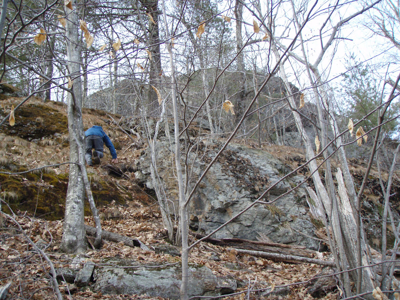
The ledges were massive and the terrain around them very steep. The jagged, lichen and grass covered rock all around was beautiful. We spotted a split area where we could make a steep climb. Our climb payed off. As we walked out onto the ledge we were treated to a spectacular 180 degree view. We had searched so many trails on the reservation in search of a great view and finally found it!

We could look down onto the woods and mountains that Piper Mt. Road runs through, with Piper Mt. on straight ahead. We could see Bowser Pond frozen in ice and the heron rookery behind it. Phoebes Nable mountain was visible as was the logging/skid roads that we had walked and plan to build trails on. Beyond, the Blue Hills Range was seen including Nubble Mt. in Farmington, Blue Job and Prospect Mt. It was such a lovely, peaceful spot!

Deer and Moose also seemed to like the area as their droppings were plentiful in the area. We made our way up to the top of the hill where it forms a small wooded knob area of rock and vegetation. We decided to name it Beauty Knob and Beauty Ledge. The elevation at the highest point of the knob according to the GPS was 1,238 feet. We were so thrilled with this find, we vowed to return the next day to begin building a trail to it! After exploring two other ledge tops, both with a limited view in one direction, we headed back down. 

Next day we were both up and ready to go nice and early. We gathered together food, tools and our bags and headed out to complete our mission. We drove up and parked at the clearing at 9:30am. To start we determined where the trail head should be. There was a nice clump of rocks that would be nice to put a trail along, so we decided to start the trail here where there was also a nice birch tree we could affix a trail sign too when the time comes.

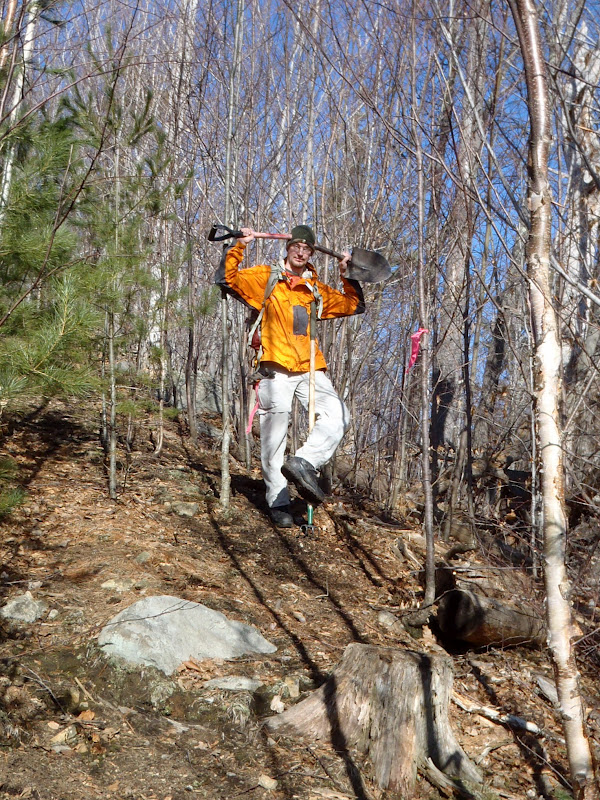
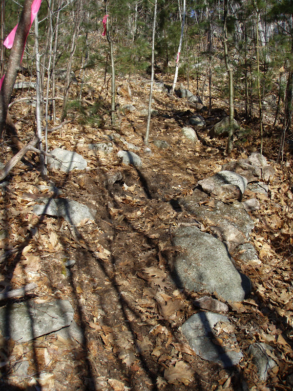
Scott took tree cutting duty and began cutting with the clippers. I got stump/rock removal & raking duties. First I headed through the woods with my pink marker tape to mark-out a good trail route. The plan was to bring the trail through the easiest to "clean" sections and by any interesting features.

The job was difficult. It took a lot of cutting, digging stumps and rocks out, raking away the leaves, sticks and loose rock from the trail. But it was a beautiful February day with mild temperatures and a brisk breeze that kept things comfortable all day. We worked well together as we worked our way around boulders, along a rock wall and through a steep pine glade. At about 12:30 we were getting tired and needed to eat some lunch. So we decided to hike to the ledge to eat.

On the way up we discovered a large rock that resembled an animal. "Snapping Turtle Rock" we named it. The hike up the ledge was difficult. Lunch bags in hand and steep, icy climbing wasn't easy! As we negotiated the rocks and steep bankings we searched for a path that would be easiest to put a trail. We finally decided it best to keep the trail below the steep, rocky area and follow the boulders below around to the back of the ledge.

We finally worked our way up to the ledge and enjoyed our food and the glorious view we were working hard to build a trail to, so that others could also enjoy this view. After eating we explored and tried to figure out the best way to get over or around these massive ledges. We got back around to Snapping Turtle Rock and decided this is as far as we would cut to today until we could mark a good route to the top of the ledge.

We began our work again and kept at it until we reached the rock. We were just about spent on energy and ready to call it a day. We accomplished a lot! We cleared out the trail and did a really nice job. No injuries aside from a few whips in the face from branches, sore bodies and hands and a broken shovel...oops! The trail will need some touch-ups but is ready to go for hiking. Once we finish up to the ledge we can blaze it and get the map updated! Looks like we will be back at it next weekend if this awesome weather continues. I mean really...trail building in February....c'mon! How often can that be done!Check some before and after photos below!


Wednesday, February 8, 2012

MMR Map/Directions/Trail Descriptions

- Visit the Forest Society's website for more info. and the updated map -

Moose Mountains Reservation in Middleton and Brookfield, NH covers roughly 2,500 acres and in conjunction with town land, Ellis Hatch and Copple Crown conservation areas it is one of the largest non-developed forests in Southern New Hampshire! It is a crucial tract of land, harboring important headwaters of the Salmon Falls River.

The forests and hills contain a host of native wildlife such as black bear, moose, porcupine, coyote and a heron rookery. As well as a plentiful array of wildflowers including some rare orchids, wild columbine, rock harlequin, sundew's and wild berries. Hiking, bird watching, fishing, hunting, cross-country skiing, snowmobiling and other low impact outdoor recreation can be enjoyed on the property. Hiking trails are a combined woods roads and foot paths taking you to several ponds and marshes, open summit peaks and ledges, early 1800's cemeteries and old farmland. There is plenty to explore here!

The main trails are signed and blazed and we continue to work on getting the less traveled trails cleared out and marked as well.

DIRECTIONS TO MAIN PARKING/KIOSK: directions obtained from Google Maps


* Please drive carefully along the narrow road and watch for other drivers and residents.
* Currently there may not be winter parking access and parking is not permitted along the road or at the parking lot entrance.

From NH Rt. 16 Spaulding Turnpike (Portsmouth/Rochester/Milton/White Mountains)
About 3.3 miles from Rt. 16 in Milton, NH

-From Rt. 16 Spaulding Turnpike in Milton turn onto NH 125/153 South (Main St.)
-Take the 2nd right onto NH 153 South (Middleton Hill Rd.)
-Take the 1st right onto Ridge Rd.
-Take the 2nd right onto New Portsmouth Rd. (sharp corner w/ cemetery on a hill)
-Follow this road to it's end at a small parking area and kiosk.

From NH Rt. 28 (Wolfeboro) 
About 11.2 miles from Rt. 28 in Wolfeboro, NH

-From NH Rt. 28 (South Main St.) in Wolfeboro turn onto Kings Highway (Middleton Rd.) at the sharp corner.
-Follow for almost 7 miles and turn left onto Ridge Rd. at the Town Offices
-After about 1.6 miles turn left onto New Portsmouth Rd. (sharp corner w/ cemetery on a hill)
-Follow this road to it's end at a small parking area and kiosk.

From NH Rt. 11 (Concord/Laconia/Alton/New Durham/Farmington) 
About 10.2 miles from Rt.11 in Farmington, NH

-From NH Rt. 11 in Farmington turn onto NH 75 East (Central St.)
-Turn left onto NH 153 North (Charles St./Kings Highway)
-Follow for nearly 6 miles and turn right onto Ridge Rd. at the Town Offices
-After about 1.6 miles turn left onto New Portsmouth Rd. (sharp corner w/ cemetery on a hill)
-Follow this road to it's end at a small parking area and kiosk.

TRAIL DESCRIPTIONS:

<GREEN – Easy and Moderate grades> <BLUE – Moderate some steep/loose footing> <RED – Difficult with steep/loose footing>

PHOEBES NABLE MT. LOOP ~ 2.2 MILES ~ 550' ELEVATION GAIN:
- via Phoebes Nable Mt. trail, Phoebes Nable Loop trail and Burrows Farm trail

BEAUTY LEDGE LOOP ~ 3 MILES ~ 600' ELEVATION GAIN:
- via Burrows Farm trail, North trail, Beauty Ledge trail, Beauty Knob tr, North tr, Burrows Farm tr

Phoebes Nable Mt. Trail ~ .6 MILES ~ 550' ELEVATION GAIN: Starting at the kiosk climb moderately using several logging roads and making several steep climbs. The trail begins at the bottom of the parking lot over rock stepping stones. Follow the path for 70 yards and bear left onto a woods road. Continue for another 100 yards climbing stone steps and at .1 miles take a sharp right onto another woods road. Climb a steep hill with restricted views behind you. The trail levels out and then climbs again. At .3 miles turn left and again climb steeply along a skid road. Ferns grow plentiful along this section and as the trail levels out the woods begin to open up around you. The trail hugs a patch of pine trees and makes a sharp right onto a foot path, curving left and then right again as you make the final push to the summit. A view will open up on the left and at .6 miles the spur trail leads 25 yards to the summit of Phoebes Nable Mt. 1,178'. There is a 180* view down to the valley below across several marshes and ponds and out to the Teneriffe range and into Maine. Panning right you look over to the Blue Hills range. From here you can make a loop via Loop trail and Burrows Farm trail.

Burrows Farm Trail ~ 1.1 MILES: From the parking lot Kiosk this trail is the heart of the trail system connecting you to all of MMR's scenic points. Begin at the green gate along a woods road that runs parralell to a brook just through the trees. At .2 miles on the left is the Hall Spring. At .3 miles you cross a bridge over the brook and bear left away from North trail to the right. Climb gradually and cross over the brook again. At .8 miles turn left at the Moose Mountains trail junction, crossing the brook once again and past another green gate. Make a short climb and at .9 miles you enter out to an open field. To the left down the hill is the Steven's Cemetery. Just ahead and to the right you can make a short climb to the Burrows Farm home site. A large rock with a plaque sits here. Continuing on the main trail pass the Burrows Cemetery on the left and near the top of the field bear left at the sign post. There are views across the field to the long ridge which once was sheep pasture hence the name Bald Mt. Cross the field and enter the woods where at 1.1 miles the Burrows Farm trail ends at the Phoebes Nable Loop trail.

Phoebes Nable Loop Trail ~ .5 MILES
1.6 MILES ~ 550' ELEVATION GAIN (from parking lot via Burrows Farm trail): This newly constructed (2015) trail begins at the end of Burrows Farm trail, just as you enter the woods from the field. The trail begins almost level until you come to the first switch-back. At the top of the switch-back you climb slightly and pass along a couple rock boulders. You then pass alongside a ledge and gently climb to the second switch-back which passes through a pine glade. The trail enters back into hard-wood than descends slightly again through pine forest before climbing to a stone staircase built by volunteers. From here you make the final climb slightly right past more ledges and take a sharp left onto the old woods road (lower portion no longer maintained). The summit of Phoebes Nable Mt. is reached in 150 feet.

Bowser Pond Trail: Beginning on New Portsmouth Rd. a few hundred feet below the kiosk this woods road climbs moderately before leveling off (blue blazes). Bear right shortly past this and follow the unmarked road (Private Property – stay on trail) to the shore of Bowser Pond with excellent views up to Beauty Ledge. Back on the main trail continue along level ground passing a short path on the right to the West shore of the pond and soon ending at Piper Mt. Trail.

North Trail: Beginning off of Burrows Farm trail past the river crossing this logging road serves as a connection to the trails on the East side of the Reservation. Grades are moderate and offer various restricted views along the way. The trail bears right at a large clearing and continues past a gate.

Moose Mountains Trail: Beginning from Burrows Farm trail make a very steep, rocky climb to an open, pretty rocky-ridge pitch pine forest with various restricted views. (Upper section crosses onto Private Property – stay on trail.)

Piper Mt. Trail: This woods road makes various steep drops and climbs down to Bowser Pond. It bears left at Bowser Pond trail and curls around a marsh area before climbing up to Piper Mt. Road. Crossing onto Middleton Town Forest take a right and at the top of the hill another right onto a foot path to Piper Mt. and it's ledges.

Beauty Ledge Trail ~ 1.2 MILES ~ 600' ELEVATION GAIN: The trail begins via Burrows Farm trail and .4 miles up North trail. Trail head is on the left at a collection of rock ledge. The trail climbs steeply up a banking of young pine and birch making some small switchbacks and passing various large rocks and a rock wall. The trail levels off and you pass Snapping Turtle Rock at ___. From here bear right passing several other large rocks as you follow the base of the massive ledge. The trail switchbacks through a pine glade then breaks away from the ledges and then coming back to them again. At a sharp left make a short steep climb up stone steps and switch back up a steep section. The trail levels again as you pass an attractive granite lichen hill with wild columbine and rock harlequin in season. The trail curves around this hill, over the top of it and back down again to the Beauty Knob trail junction at .4 miles. Here you can make a loop on your way back (keeping right at the bottom of Beauty Knob trail onto North trail). From the junction hike ahead towards the knob and climbing around it's North end. Pass just a few feet from Beauty Knob (1,238') on the left and continue, bearing left and out to the top of the ledges. Here there is a partial view North to Milton Mills. Now descend down rock with some loose footing and across to Beauty Ledge (.5 miles) where the trail ends at a 180* view looking below to Bowser Pond and several marshes and out to the Piper Mt. range, the Teneriffe Mt. range, Blue Hills Range, Prospect Mt. and Phoebes Nable Mt. at the far right and beyond out to the horizon to the Mt. Agamenticus in York, Maine. 

Beauty Knob Trail ~ .2 MILES: This trail begins from the large clearing at the upper section of North trail at 1 mile. It can be used as a loop with Beauty Ledge trail. Following blue blazes climb easily through young forest taking a left past broken rock where a porcupine lives. Walk over a sandy area where a tree fell over leaving exposed sand. Look down just past this on the right...there are snake skin orchids growing here! Begin climbing as you switchback moderately through a pine glade over a few large stones. Entering back into hardwoods make a short level walk to Beauty Ledge trail. Take a right to climb to the knob and ledges.

Sunday, February 5, 2012

Phoebe's Nable Mt. Loop 2/5/12

"Marking the New Loop Trail" (pictures)


Having had a long week and neither of us wanting to rise early in the morning to head to the White's, we decided to head for Moose Mountains again. We had been there 2 weekends ago in snow shoes to plot out what will be the new Phoebe's Nable Mt. Loop trail. This time around what little snow we had was now just a few inches of crusty snow, no snow shoes required...though micro spikes would have come in handy. Especially on the North side of the mountain!

This time around we decided to do the same loop but this time mark the trail with pink marker tape. Also we had a GPS from the Forest Society so we can start recording the new trails to add to the map down the line. I figured this would be a good practice run to see if I could get a handle of it and to see if it worked. I got waypoints, scenic views, junctions and the summit marked on the GPS along the way. I don't think I got the actual trail route recorded though. So I will need to figure it out some more.

Near the summit of the mountain Scott stopped us as he heard a noise. Sure enough a moose was crashing through the trees nearby, no doubt spooked by our presence. It was a beautiful day. Cold but warm enough when moving to not need our winter jackets or any gloves! The Burrows Farm trail below the field...a snow mobile trail in winter was lacking snow almost completely in spots, not something they like to see I'm sure. The stream along the Burrows Farm road was nice and icy creating some neat formations.

Sunday, January 22, 2012

Phoebe's Nable Mt. Loop 1/22/12

"A Snowshoe Search for a New Loop Trail!" (pictures)

Scott and I headed out Sunday morning to Castle in the Clouds to hike Mt. Roberts. We left the house a little late after trying to get all the winter gear together. And by the time we reached Wolfeboro we just weren't in the mood for the drive and what might be a long, cold hike of which we had really no practice this year for. So we decided to pull into Dunkin Donuts to grab a coffee and Maple Sausage bites...mmmm...and head back in the opposite direction for Moose Mountains Reservation. We parked in the unplowed parking lot behind another vehicle. Once geared up Scott motioned we should head up the logging road to search out a new hiking route we had been wanting to find. I eagerly agreed!

We began up this road which leaves from the parking area (left side before passing the gate) at 10:20am. It was a cold 32 degrees but the sun warmed us up quick. At the junction with another logging road we took a left and at the next junction a right onto another logging road. From here the trail climbs 300 feet and levels out. Partial views open up to the South and North and East to the various Moose Mountain peaks. The trail passes another road on the right that descends back down to the other road. Then a skid road enters on the left.

We went left here and made another moderate climb through the snow. While there was only a foot of snow, it was just enough for the snow shoes. We could use a little more snow on the ground, that's for sure! There were various tracks through the snow from rabbits, a fox and mice. After passing through open woods the road swings North and enters some trees. The Phoebes Nable Summit was 100 feet away. This was much easier than I had thought! We took some pics and headed down the other side to take Burrows Farm trail down.

We entered the field and followed the snow mobile trail down and were back on unbroken snow past the North Road junction. The only other sign of people up here today was a track of cross country skies which left the field and ended back where the other vehicle had been parked. This was a great loop hike! We finished about 11:45am. The hike seemed longer than that, but guess our legs need some work! We plan on trimming and blazing this trail in the Spring, it will add a lovely loop option to this mountain and property! 

Tuesday, January 17, 2012

Bowser Pond 1/16/12

"Dusted off the Snowshoe's" (pictures)

Monday not being as cold as the weekend was we did a small snowshoe walk up to Bowser Pond. January 16 and the snowshoes where still in the closet collecting dust! With a few inches of snow on the ground we could at least get a practice run in. We parked at the end of Bowser Pond trail a few hundred feet from the kiosk. We crossed the not-so-safe bridge and up the old logging road.

Sections where rocks jutted up were not very good for the snowshoes. But most of the walk was fine and it was so nice to get out for a walk and to visit Bowser Pond which we had not been to in a few months. The pond was frozen and the view across it to the collection of mountains was neat, being able to see what they look like without leaves blocking the ground. We then retraced our steps back and headed home.